
And for my next trick, I’ll be climbing a mountain in the desert!
Wait, hang on, I’m getting a note here. What’s this? You say we’ve already had one desert mountain? Well, what about second desert mountain?
For better or worse, the fifth highpoint on the list is Black Mesa, a dry and unshaded hike through almost-desert and almost-prairie. It’s a landscape that reminds you aggressively of the far West Texas desert, despite being hundreds of miles away. But we’ll get into that.
Perhaps the most notable part of this trip: I brought friends! After all the time spent bellyaching about doing things alone on Greylock, it seems only fitting that on the next highpointing endeavor, no one would need to go it alone. Two of my best friends in the world agreed to roll out with me on this one, and as always, having them at my back made the sky seem a little bluer and the trail a little shorter after all. Thanks for coming, y’all.
That said, let’s hop in to covering the trip itself.
What’s Black Mesa?
Black Mesa is a miles-long plateau that extends through Colorado, New Mexico, and Oklahoma’s panhandle. The Oklahoma portion of the mesa includes the tallest point in the state of Oklahoma at 4,973 feet above sea level, beating several aspiring peaks in the Wichita Mountains in the southeastern part of the state.
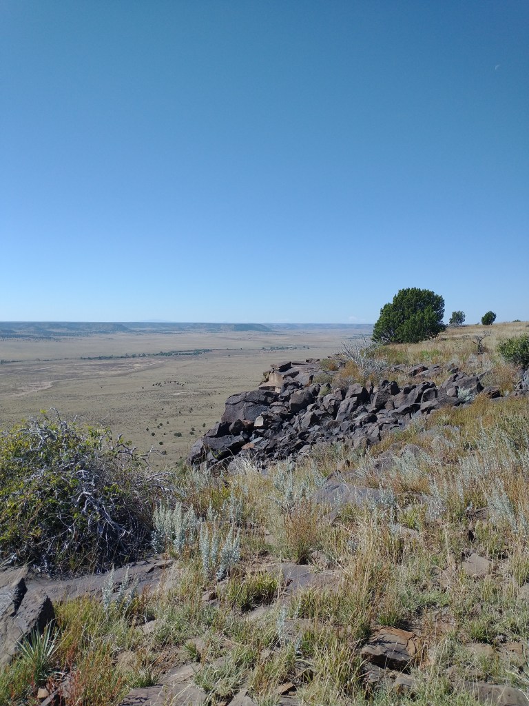
Fun fact: The name comes from the volcanic rock spread over the area, like frosting on a sandstone cake. Dark, delicious igneous rock. Yum.
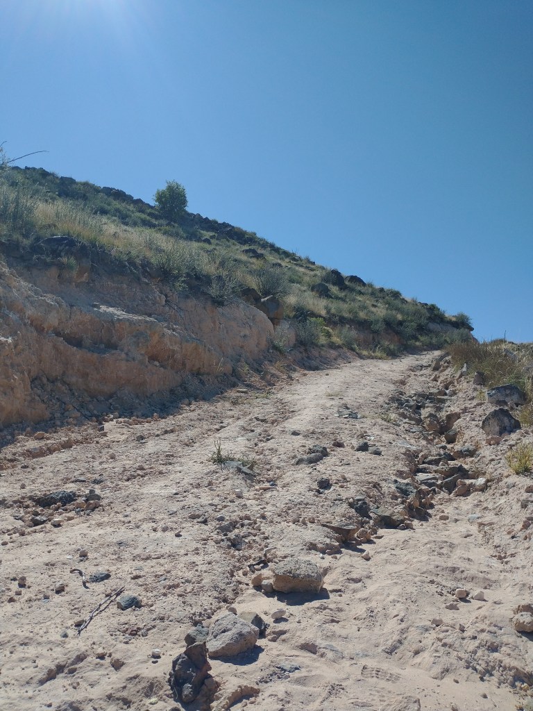
The highpoint trail itself is an 8.8 miles there-and-back route—with the funniest incline I’ve ever seen on a trail map. The 748 ft of incline we’d cover was all condensed into about half a mile of trail. The rest of the hike? Completely without incline whatsoever. So we’d be walking for a couple miles of completely flat trail, with a sharp incline for about a half mile or so (maybe even less), followed by another couple of miles of flat on top of the mesa itself.
On arrival, the topography matched the map to the letter.

Look at that. It’s all so flat. Except for that one Really Not Flat bit (which is helpfully also, itself, flat on top.) I love geography.
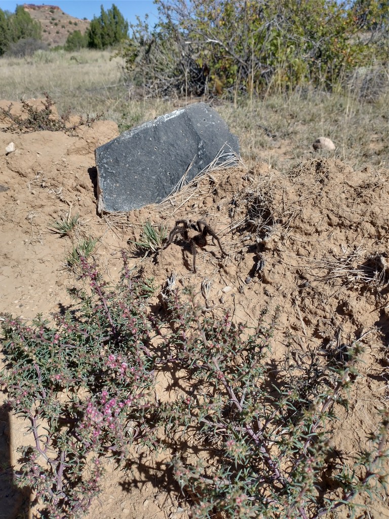
Unbothered, moisturized, in the arachnid lane
We started our hike around 10:00 am, in crisp wind on a bright blue morning. Above us, the mesa loomed—as did several other, equally-imposing looking mesas, all dotted with the same small green bushes. Nothing tall grew here but the rocks themselves.
I looked around from the trailhead, and wondered out loud which of the long, flat plateaus we’d be climbing that day. The trail claimed to be eight miles—surely it couldn’t be the one we’d parked next to? That seemed far too easy. But a confirmation from the map proved our destination the correct mesa, indeed. Nothing for it, then, but to get started.
The first few miles of entirely flat trail passed quickly, punctuated by several wildlife sightings. The dust at our feet held several surprises, for those with quick eyes (and hands, if you’re my one snake-loving friend). We saw a tarantula ambling along, unbothered and in it’s lane—although probably not moisturized, given the climate.
Shortly after, we nearly stepped on a young male Eastern hognose! One of the day’s finest sightings. One or more members of the party may have been moved to tears by this event. I can neither confirm nor deny, simply affirm that snakes are indeed, great.
Granola and M&Ms under the big blue
After a few calm miles of dusty, flat, and rock-strewn terrain, the trail turned upwards towards the only real incline we’d encounter on this highpoint trail. A wide rocky track wound sharply upwards in a couple of firm switchbacks that would take the air out of your lungs real quickly if you took them at a challenging pace.
But on that clear morning, we weren’t in a hurry. We took the incline slowly, picking our way up the lonely trail and resting at the mile marker bench. It seemed a shame to rush things, with the wide prairie starting to spread out below us as we climbed, and miles of undeveloped land stretching out in every direction, as far as the eye could see.
Part of me wanted to hustle—I had put my Fitbit on that morning hoping to get a good cardio workout on the books that day—but by the time we got to the third mile bench, I’d accepted the new pace. I have so many opportunities to go fast, and so few to do things with people who mean something to me. Why not match their pace? The point is the people, not the Thing Abigail Wants to Do Right That Moment Or She’ll Die (Probably).
We sat on and around the bench, eating granola and M&Ms under a devastatingly blue sky. It was good.
From the third mile bench, we ambled upwards, boots against white rock. Most of the 700 feet or so of elevation gain were behind us now, and we could turn near the top and look almost all the way straight down to the path we’d taken to get there.
A last scramble, and that was it—we broke out onto the long, flat surface of the mesa, with nothing but dry waving grass for miles in every direction but down.
It’s a summit, we swear!
Oklahoma’s highpoint is somewhat misleading. At least in the sense that there’s not really a summit, so much as a long, evenly flat section of land on the mesa that is technically higher than all other sections of land, and has had an obelisk placed on it in an arbitrary location. At least, it seems arbitrary, to the naked eye.
My highpoint photo makes me laugh.
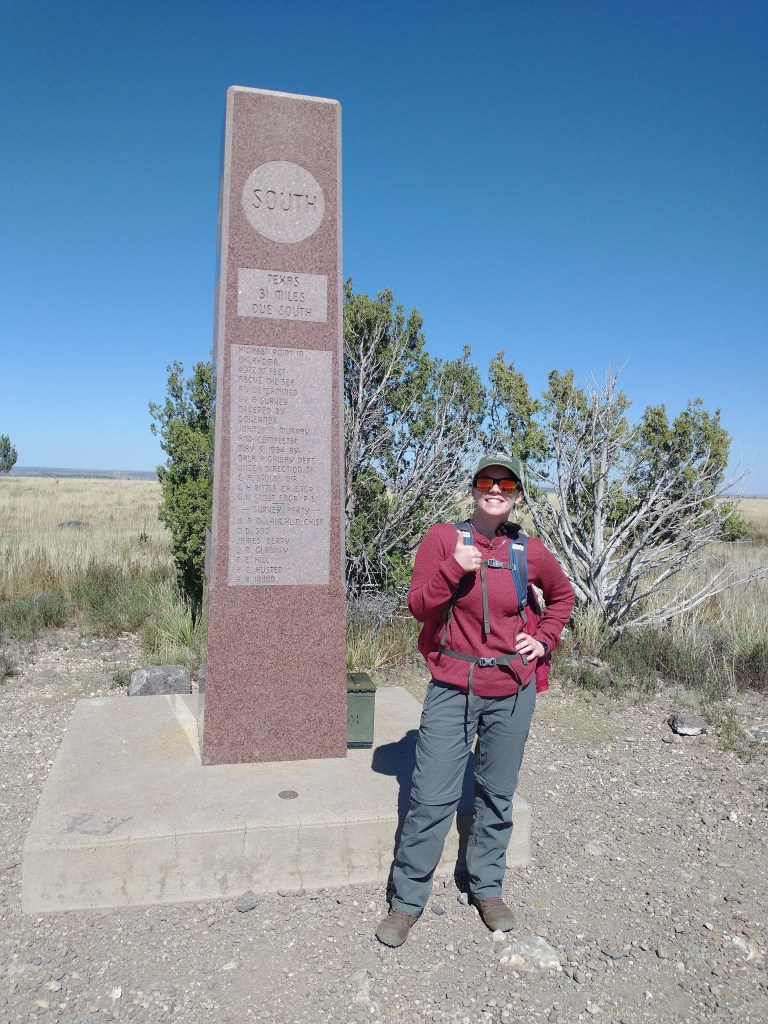
It’s a picture that really downplays the achievement. The mesa looks absolutely devoid of topography in any direction, and you’d never guess there was a trail, let alone one with any elevation gain. It’s just flat as far as the eye can see.
But, I promise, we did a climb! It was a rigorous 700 feet of elevation gain, even.
That said, if you need the feeling of having accomplished something, you can follow the trail all the way to the turnaround point at the end of the mesa, where you can look down over the wide prairie and survey your work. We looked out over a landscape dotted with cactus and juniper, waving grass and shrub oak, and felt the wind whip our faces in a highly satisfactory manner. Mission accomplished!
The obelisk marking the summit of Black Mesa shows the distance from the highpoint to each of the four closest states—Texas, New Mexico, Colorado, and Kansas. (Turns out that Cimarron County, OK is the only county in the U.S.A to touch 4 different states.) New Mexico is just a quarter mile away, from that point.
You can also sit on the concrete next to the obelisk, and write your name in the high pointer’s book, with a short message about your hike (and the snakes you saw along the way).
Grasshoppers of unusual size
With our purpose fulfilled, we began our route back down the trail, following the top of the mesa back to the more vertical parts of the route. The sun beat down, now hot despite the wind, and I adjusted my jacket even higher on my backpack to cover my neck from the rays. (This would later prove to have been highly ineffectual, in the sunburn department).
We trailed along, a little slower than we’d come, taking our time and making commentary on the egregious size of the local grasshoppers.
Ambling along the long, flat top of the mesa, I thought about the first of these highpoints I did, Texas. Being out here under the flat sky stretching from horizon to horizon, dust and rock under my boots—it reminds me a lot of that trip last year. We’re hundreds of miles from West Texas, but the desert is a big place. Even if this is a little more prairie and a little less cactus.
Just as we were about to hit the decline again—we saw her. A beautiful lone pronghorn antelope trailed along parallel to us, belly-deep in the waving grass. We all stopped to stare at her, and the phones came out to grab pictures.
There she goes. Fastest hoofed animal in North America.
I held my breath, not bothering to even grab at my own phone, as she bounded into the distance as fast as she came. Seeing an animal in the zoo in the Texas exhibit is one thing. Seeing it live and wild in the home of its birth is something else entirely.
She disappeared into the brush on the other side of the mesa… We waited about 0.5 seconds before bursting into a chorus of, “Holy SHIT, dude.” Snakes, tarantulas, and an antelope? The shortgrass prairie crawled with life!
Time flies when you’re hiking with buds
Once we got to the descent, the rest of the trail flew by in quick conversation about what to eat that evening, and commentary about the length of the trail. By the time we’d made it halfway down, we’d picked out a Cajun place in Amarillo, with an absinthe selection that would put several reputable establishments in Austin to shame. This included reading the menu out, line item by line item, so everyone could have ample time to pick out their selections.
Even as the sun rose and tilted in the sky, and we put miles behind us slowly but surely—it didn’t feel like long at all before we came up on the car again.
That’s half the fun of doing things with friends. You can’t beat good company for a good time.
So, that’s Black Mesa. Not the hardest highpoint, not the easiest, but lovely all the same. Eight miles and some change in a wide October, under a big prairie sky.
Five down, forty-five to go!

I finally hiked Black Mesa this past August, and it was exactly as you described. Thank God I met someone at the trailhead, and we ended up hiking together. We talked the entire way, which made the miles fly by. A complete 360 from the day before when I hiked Wheeler Peak in New Mexico!